
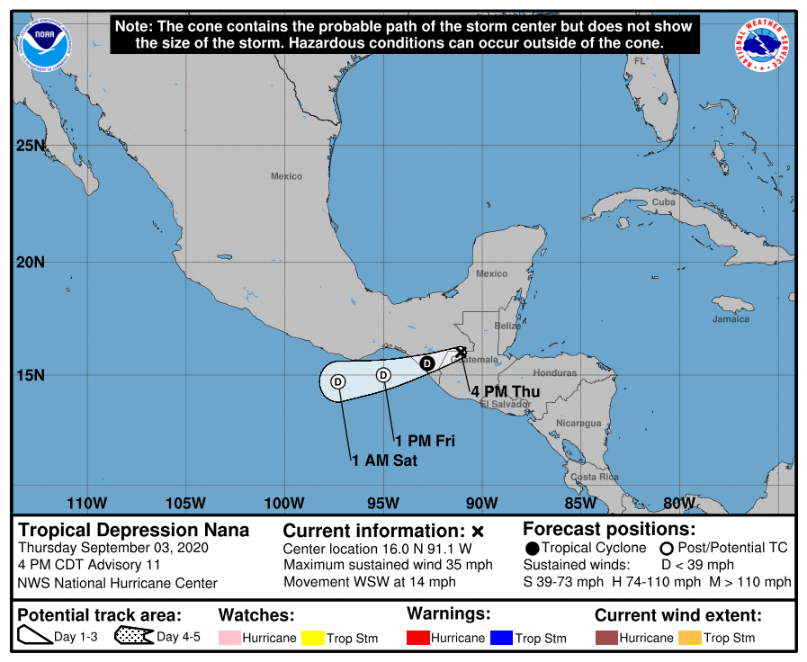
TROPICAL DEPRESSION NANA Coastal Watches/Warnings and Forecast Cone for Storm Center JavaScript/Active Scripting must be enabled to view other versions of this maps. * If the storm is forecast to dissipate within 3 days, the “Full Forecast” and “3 day” graphic will be identical Click Here for a 5-day Cone Printer Friendly Graphic How to […]
Category Archives: General Strong Weather Info
Advisory #018 Forecast Track [kmz] – Post-Tropical Cyclone Iselle (EP4/EP142020)
KMZ last updated Sun, 30 Aug 2020 20:41:41 GMT Source link
ATCF XML Prototype [xml] – Tropical Depression Laura (AT3/AL132020)
Issued at Fri, 28 Aug 2020 21:06:54 GMT. This is only a prototype and the file format may change without notice. Source link
TROPICAL DEPRESSION THIRTEEN-E
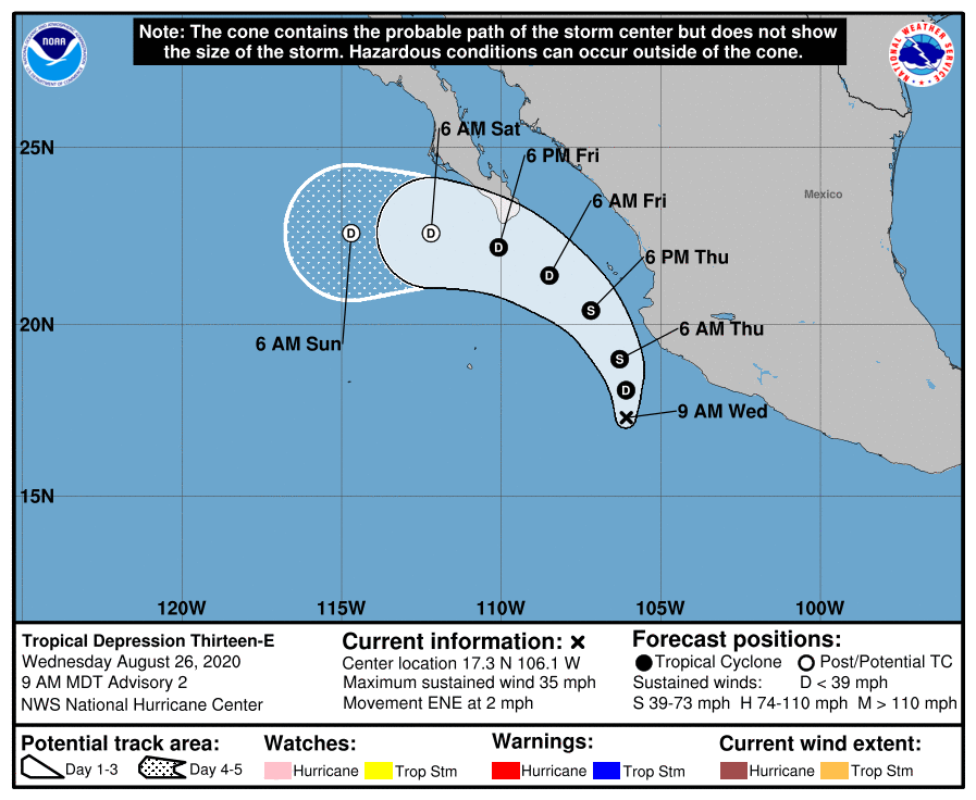
TROPICAL DEPRESSION THIRTEEN-E Coastal Watches/Warnings and Forecast Cone for Storm Center JavaScript/Active Scripting must be enabled to view other versions of this maps. * If the storm is forecast to dissipate within 3 days, the “Full Forecast” and “3 day” graphic will be identical Click Here for a 5-day Cone Printer Friendly Graphic How to […]
Local Statement for Laura (New Orleans / Baton Rouge, LA)
437 WTUS84 KLIX 241840 HLSLIX LAZ034>037-039-040-046>050-056>072-MSZ068>071-077-080>082-250245- Tropical Storm Marco Local Statement Special Advisory Number 18 National Weather Service New Orleans LA AL142020 140 PM CDT Mon Aug 24 2020 This product covers Southeast Louisiana and South Mississippi **Watches and Warnings Will Be Issued Later This Afternoon for Laura** NEW INFORMATION ————— * CHANGES TO WATCHES […]
Preliminary Best Track Points [kmz] – Tropical Depression Thirteen (AT3/AL132020)
KMZ last updated Thu, 20 Aug 2020 18:06:38 GMT Source link
HURRICANE GENEVIEVE
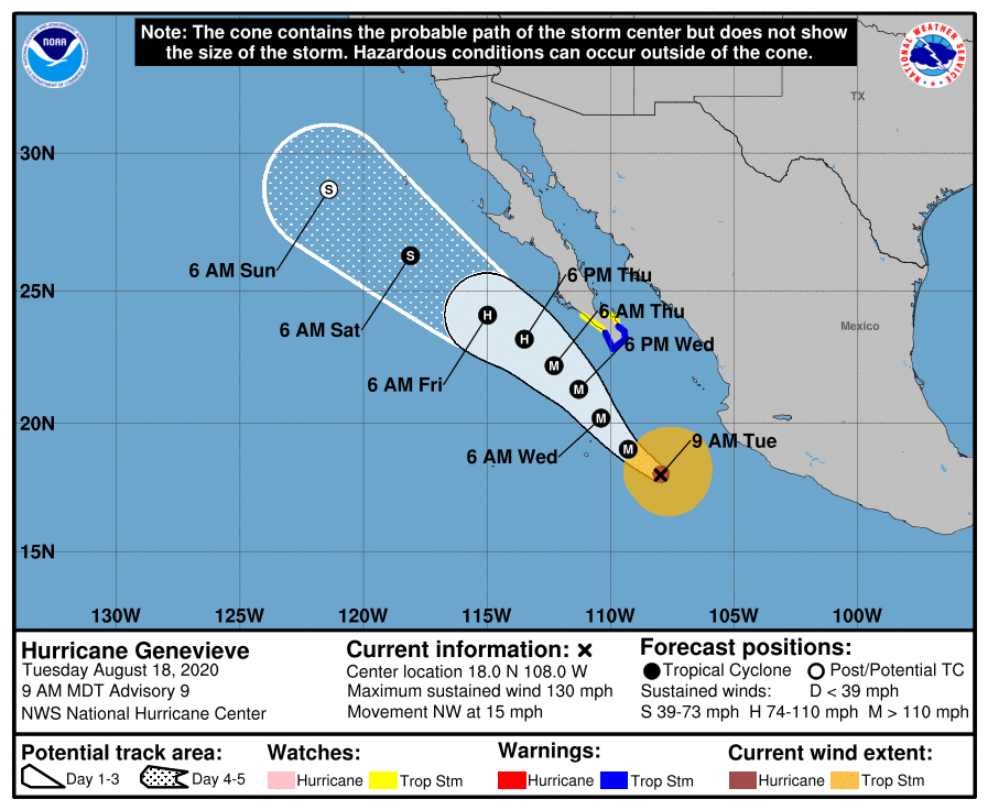
HURRICANE GENEVIEVE Coastal Watches/Warnings and Forecast Cone for Storm Center JavaScript/Active Scripting must be enabled to view other versions of this maps. * If the storm is forecast to dissipate within 3 days, the “Full Forecast” and “3 day” graphic will be identical Click Here for a 5-day Cone Printer Friendly Graphic How to use […]
Tropical Depression Ten-E Public Advisory
712 WTPZ35 KNHC 141432 TCPEP5 BULLETIN Tropical Depression Ten-E Advisory Number 6 NWS National Hurricane Center Miami FL EP102020 800 AM PDT Fri Aug 14 2020 …DEPRESSION PERSISTS FOR NOW… SUMMARY OF 800 AM PDT…1500 UTC…INFORMATION ———————————————- LOCATION…13.6N 131.9W ABOUT 1575 MI…2535 KM WSW OF THE SOUTHERN TIP OF BAJA CALIFORNIA MAXIMUM SUSTAINED WINDS…35 MPH…55 […]
Advisory #003 Forecast Track [kmz] – Tropical Depression Eleven (AT1/AL112020)
KMZ last updated Wed, 12 Aug 2020 08:51:48 GMT Source link
Tropical Storm Elida Forecast Discussion
000 WTPZ44 KNHC 100851 TCDEP4 Tropical Storm Elida Discussion Number 6 NWS National Hurricane Center Miami FL EP092020 300 AM MDT Mon Aug 10 2020 After the earlier burst of deep convection and the development of a small 10-nmi-wide low- to mid-level eye noted in passive microwave satellite imagery, convection has waned somewhat and the […]