Earthquake: 2024-07-11 10:13HKT M7.0 [6.07N, 123.15E] in Mindanao, Philippines http://openstreetmap.org/?mlat=6.07&mlon=123.15.
Source link
Tropical Depression Beryl Public Advisory
000
WTNT32 KNHC 090234
TCPAT2

BULLETIN
Tropical Depression Beryl Advisory Number  42
NWS National Hurricane Center Miami FL       AL022024
1000 PM CDT Mon Jul 08 2024

...FLOODING RAINS AND THE RISK OF TORNADOES CONTINUE ACROSS
PORTIONS OF EASTERN TEXAS, WESTERN LOUISIANA AND ARKANSAS...
...THIS IS THE LAST NHC ADVISORY...


SUMMARY OF 1000 PM CDT...0300 UTC...INFORMATION
-----------------------------------------------
LOCATION...32.8N 94.3W
ABOUT 70 MI...110 KM ENE OF TYLER TEXAS
MAXIMUM SUSTAINED WINDS...35 MPH...55 KM/H
PRESENT MOVEMENT...NNE OR 15 DEGREES AT 17 MPH...28 KM/H
MINIMUM CENTRAL PRESSURE...999 MB...29.50 INCHES


WATCHES AND WARNINGS
--------------------
There are no coastal watches or warnings in effect.


DISCUSSION AND OUTLOOK
----------------------
At 1000 PM CDT (0300 UTC), the center of Tropical Depression Beryl
was located near latitude 32.8 North, longitude 94.3 West. The
depression is moving toward the north-northeast near 17 mph (28
km/h) and this motion is expected to continue during the next
couple of days.

Maximum sustained winds are near 35 mph (55 km/h) with higher gusts.
Weakening is forecast, and Beryl is expected to become a remnant
low on Tuesday.

The estimated minimum central pressure is 999 mb (29.50 inches).


HAZARDS AFFECTING LAND
----------------------
Key messages for Beryl can be found in the Tropical Cyclone
Discussion under AWIPS header MIATCDAT2, WMO header WTNT42 KNHC,
and on the NHC website at hurricanes.gov/text/MIATCDAT2.shtml.

STORM SURGE: Water levels remain elevated along the Texas coast,
but should continue to recede overnight.

For a complete depiction of areas at risk of storm surge inundation,
please see the National Weather Service Peak Storm Surge Graphic,
available at hurricanes.gov/graphics_at2.shtml?peakSurge.

TORNADOES: Several tornadoes are possible through tonight across
parts of east Texas, Louisiana, and Arkansas. The tornado risk will
spread into southeast Missouri, northern Tennessee, Kentucky,
southern Illinois, southern Indiana, and Ohio on Tuesday.

RAINFALL: Heavy rainfall of 3 to 5 inches, with locally higher
amounts, is expected across portions of far southeastern Oklahoma,
Arkansas and southern Missouri through Tuesday. Local flash and
urban flooding is expected.

For a complete depiction of forecast rainfall and flash flooding
associated with Tropical Depression Beryl, please see the National
Weather Service Storm Total Rainfall Graphic, available at
hurricanes.gov/graphics_at2.shtml?rainqpf and the Flash Flood Risk
graphic at hurricanes.gov/graphics_at2.shtml?ero

For a list of rainfall observations (and wind reports) associated
this storm, see the companion storm summary at WBCSCCNS2 with the
WMO header ACUS42 KWBC or at the following link:
www.wpc.ncep.noaa.gov/discussions/nfdscc2.html

For a list of rainfall observations (and wind reports) associated
this storm, see the companion storm summary at WBCSCCNS2 with the
WMO header ACUS42 KWBC or at the following link:
www.wpc.ncep.noaa.gov/discussions/nfdscc2.html

SURF:  Swells generated by Beryl are expected to gradually
decrease during the next day or so. Please consult products from
your local weather office.


NEXT ADVISORY
-------------
This is the last public advisory issued by the National Hurricane
Center on this system.

$$
Forecaster Cangialosi
Strong Earthquake Report M6.0 [26.96N, 138.73E] near Ogasawara Islands, Japan Region (04:09 HKT 08/07/2024)
Earthquake: 2024-07-08 04:01HKT M6.0 [26.96N, 138.73E] near Ogasawara Islands, Japan Region http://openstreetmap.org/?mlat=26.96&mlon=138.73.
Source link
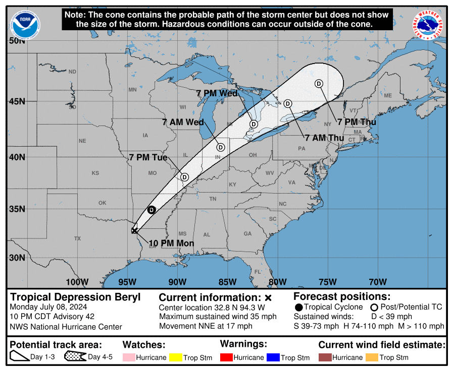
TROPICAL DEPRESSION BERYL
TROPICAL DEPRESSION BERYL
Coastal Watches/Warnings and Forecast Cone for Storm Center

* If the storm is forecast to dissipate within 3 days, the “Full Forecast” and “3 day” graphic will be identical
Click Here for a 5-day Cone Printer Friendly Graphic
How to use the cone graphic (video):

About this product:
This graphic shows an approximate representation of coastal areas under a hurricane warning (red), hurricane watch (pink),
tropical storm warning (blue) and tropical storm watch (yellow). The orange circle indicates the current position of the
center of the tropical cyclone. The black line, when selected, and dots show the National Hurricane Center (NHC) forecast track of the center
at the times indicated. The dot indicating the forecast center location will be black if the cyclone is forecast to be
tropical and will be white with a black outline if the cyclone is forecast to be extratropical. If only an L is displayed,
then the system is forecast to be a remnant low. The letter inside the dot indicates the NHC’s forecast intensity for that time:
D: Tropical Depression – wind speed less than 39 MPH
S: Tropical Storm – wind speed between 39 MPH and 73 MPH
H: Hurricane – wind speed between 74 MPH and 110 MPH
M: Major Hurricane – wind speed greater than 110 MPH
NHC tropical cyclone forecast tracks can be in error. This forecast
uncertainty is conveyed by the track forecast “cone”, the solid white
and stippled white areas in the graphic. The solid white area depicts
the track forecast uncertainty for days 1-3 of the forecast, while the
stippled area depicts the uncertainty on days 4-5. Historical data
indicate that the entire 5-day path of the center of the tropical
cyclone will remain within the cone about 60-70% of the time. To
form the cone, a set of imaginary circles are placed along the
forecast track at the 12, 24, 36, 48, 72, 96, and 120 h positions,
where the size of each circle is set so that it encloses 67% of the
previous five years official forecast errors. The cone is then formed
by smoothly connecting the area swept out by the set of circles.
It is also important to realize that a tropical cyclone is not a point. Their
effects can span many hundreds of miles from the center. The area
experiencing hurricane force (one-minute average wind speeds of at least
74 mph) and tropical storm force (one-minute average wind speeds of
39-73 mph) winds can extend well beyond the white areas shown enclosing
the most likely track area of the center. The distribution of hurricane
and tropical storm force winds in this tropical cyclone can be seen in
the Wind History graphic linked above.
Considering the combined forecast uncertainties in track, intensity, and size, the
chances that any particular location will experience winds of 34 kt (tropical storm force),
50 kt, or 64 kt (hurricane force) from this tropical cyclone are presented in
tabular form for selected locations and forecast positions. This information is also presented in
graphical form for the 34 kt, 50 kt,
and 64 kt thresholds.
Note: A detailed definition of the NHC track forecast cone is also available.
Advisory #003 Forecast Track [kmz] – Tropical Storm Aletta (EP1/EP012024)
KMZ last updated Fri, 05 Jul 2024 02:35:31 GMT
Source link
Advisory #018A Forecast Track [kmz] – Hurricane Beryl (AT2/AL022024)
KMZ last updated Wed, 03 Jul 2024 05:51:39 GMT
Source link
Tropical Storm Chris Public Advisory
000
WTNT33 KNHC 010257
TCPAT3

BULLETIN
Tropical Storm Chris Advisory Number   2
NWS National Hurricane Center Miami FL       AL032024
1000 PM CDT Sun Jun 30 2024

...DEPRESSION BECOMES TROPICAL STORM CHRIS...
...BRINGING HEAVY RAINFALL AND FLOODING OVER PORTIONS OF
EASTERN MEXICO...


SUMMARY OF 1000 PM CDT...0300 UTC...INFORMATION
-----------------------------------------------
LOCATION...20.0N 96.2W
ABOUT 105 MI...165 KM SE OF TUXPAN MEXICO
MAXIMUM SUSTAINED WINDS...40 MPH...65 KM/H
PRESENT MOVEMENT...W OR 280 DEGREES AT 13 MPH...20 KM/H
MINIMUM CENTRAL PRESSURE...1005 MB...29.68 INCHES


WATCHES AND WARNINGS
--------------------
CHANGES WITH THIS ADVISORY:

None.

SUMMARY OF WATCHES AND WARNINGS IN EFFECT:

A Tropical Storm Warning is in effect for...
* Cabo Rojo to Puerto Veracruz

A Tropical Storm Warning means that tropical storm conditions are
expected somewhere within the warning area, in this case within
the next 6 hours.

For storm information specific to your area, please monitor
products issued by your national meteorological service.


DISCUSSION AND OUTLOOK
----------------------
At 1000 PM CDT (0300 UTC), the center of Tropical Storm Chris was
located near latitude 20.0 North, longitude 96.2 West.  Chris is
moving toward the west near 13 mph (20 km/h), and this general
motion is expected during the next day or so.  On the forecast
track, the center will move inland early Monday.

Maximum sustained winds are near 40 mph (65 km/h) with higher gusts.
Chris will begin to weaken after landfall and will likely dissipate
later on Monday.

Tropical-storm-force winds extend outward up to 70 miles (110 km)
from the center.

The estimated minimum central pressure is 1005 mb (29.68 inches).


HAZARDS AFFECTING LAND
----------------------
Key messages for Chris can be found in the Tropical Cyclone
Discussion under AWIPS header MIATCDAT3 and WMO header WTNT43 KNHC.

RAINFALL: Chris is expected to produce rainfall totals of 4 to 8
inches across portions of eastern Mexico through Monday. Maximum
rainfall totals around 12 inches are possible across the higher
terrain of the Mexican states of Guanajuato, Queretaro, and San
Luis Potosi.  This rainfall will result in area of flooding, with
mudslides possible in areas of higher terrain.

For a complete depiction of forecast rainfall and flash flooding
associated with Tropical Storm Chris, please see the National
Weather Service Storm Total Rainfall Graphic, available at
hurricanes.gov/graphics_at3.shtml?rainqpf

WIND:  Tropical storm conditions are expected in the warning area
during the next few hours.


NEXT ADVISORY
-------------
Next intermediate advisory at 100 AM CDT.
Next complete advisory at 400 AM CDT.

$$
Forecaster Pasch
Strong Earthquake Report M6.9 [15.92S, 74.44W] near coast of Peru (13:46 HKT 28/06/2024)
Earthquake: 2024-06-28 13:36HKT M6.9 [15.92S, 74.44W] near coast of Peru http://openstreetmap.org/?mlat=-15.92&mlon=-74.44.
Source link
Strong Earthquake Report M6.4 [14.62S, 167.23E] near Vanuatu Islands (16:11 HKT 24/06/2024)
Earthquake: 2024-06-24 16:03HKT M6.4 [14.62S, 167.23E] near Vanuatu Islands http://openstreetmap.org/?mlat=-14.62&mlon=167.23.
Source link
Strong Earthquake Report M6.1 [10.54N, 62.50W] near coast of Venezuela (12:10 HKT 23/06/2024)
Earthquake: 2024-06-23 11:57HKT M6.1 [10.54N, 62.50W] near coast of Venezuela http://openstreetmap.org/?mlat=10.54&mlon=-62.5.
Source link


