
KMZ last updated Sun, 03 Sep 2023 20:37:39 GMT
Source link
POST-TROPICAL CYCLONE IDALIA
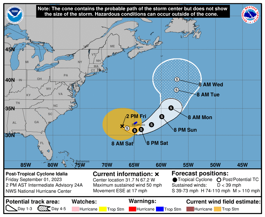
POST-TROPICAL CYCLONE IDALIA
Coastal Watches/Warnings and Forecast Cone for Storm Center

* If the storm is forecast to dissipate within 3 days, the “Full Forecast” and “3 day” graphic will be identical
Click Here for a 5-day Cone Printer Friendly Graphic
How to use the cone graphic (video):

About this product:
This graphic shows an approximate representation of coastal areas under a hurricane warning (red), hurricane watch (pink),
tropical storm warning (blue) and tropical storm watch (yellow). The orange circle indicates the current position of the
center of the tropical cyclone. The black line, when selected, and dots show the National Hurricane Center (NHC) forecast track of the center
at the times indicated. The dot indicating the forecast center location will be black if the cyclone is forecast to be
tropical and will be white with a black outline if the cyclone is forecast to be extratropical. If only an L is displayed,
then the system is forecast to be a remnant low. The letter inside the dot indicates the NHC’s forecast intensity for that time:
D: Tropical Depression – wind speed less than 39 MPH
S: Tropical Storm – wind speed between 39 MPH and 73 MPH
H: Hurricane – wind speed between 74 MPH and 110 MPH
M: Major Hurricane – wind speed greater than 110 MPH
NHC tropical cyclone forecast tracks can be in error. This forecast
uncertainty is conveyed by the track forecast “cone”, the solid white
and stippled white areas in the graphic. The solid white area depicts
the track forecast uncertainty for days 1-3 of the forecast, while the
stippled area depicts the uncertainty on days 4-5. Historical data
indicate that the entire 5-day path of the center of the tropical
cyclone will remain within the cone about 60-70% of the time. To
form the cone, a set of imaginary circles are placed along the
forecast track at the 12, 24, 36, 48, 72, 96, and 120 h positions,
where the size of each circle is set so that it encloses 67% of the
previous five years official forecast errors. The cone is then formed
by smoothly connecting the area swept out by the set of circles.
It is also important to realize that a tropical cyclone is not a point. Their
effects can span many hundreds of miles from the center. The area
experiencing hurricane force (one-minute average wind speeds of at least
74 mph) and tropical storm force (one-minute average wind speeds of
39-73 mph) winds can extend well beyond the white areas shown enclosing
the most likely track area of the center. The distribution of hurricane
and tropical storm force winds in this tropical cyclone can be seen in
the Wind History graphic linked above.
Considering the combined forecast uncertainties in track, intensity, and size, the
chances that any particular location will experience winds of 34 kt (tropical storm force),
50 kt, or 64 kt (hurricane force) from this tropical cyclone are presented in
tabular form for selected locations and forecast positions. This information is also presented in
graphical form for the 34 kt, 50 kt,
and 64 kt thresholds.
Note: A detailed definition of the NHC track forecast cone is also available.
OpenStreetMap
OpenStreetMap is a map of the world, created by people like you and free to use under an open license.
Hosting is supported by UCL, Fastly, Bytemark Hosting, and other partners.
Learn More
Start Mapping
Advisory #007 Forecast Track [kmz] – Tropical Storm Irwin (EP5/EP102023)
KMZ last updated Mon, 28 Aug 2023 14:47:23 GMT
Source link
Advisory #024 Forecast Track [kmz] – Hurricane Franklin (AT3/AL082023)
KMZ last updated Sat, 26 Aug 2023 14:50:37 GMT
Source link
Tropical Storm Franklin Forecast Discussion
066
WTNT43 KNHC 241450
TCDAT3

Tropical Storm Franklin Discussion Number  16
NWS National Hurricane Center Miami FL       AL082023
1100 AM AST Thu Aug 24 2023

Franklin appears a little better organized this morning, with a
recent convective burst near the center with cloud tops as cold as
-80C. The morning Air Force Reserve Reconnaissance mission into
Franklin indicates the storm has intensified a bit, with peak flight
level winds of 62 kt at 850-mb, SFMR winds in the 50-55 kt range,
and a recent dropsonde just to the northeast of the center reported
a surface wind of 48 kt. The initial intensity based on this
data is set at 50 kt for this advisory.

Fixes from the aircraft indicate that Franklin has begun to move to
the northeast, with the motion estimated at 040/6 kt. This motion,
or even a bit more of a turn to the east-northeast, should continue
in the short-term as a weakness persists to the north of Franklin
and its motion is more driven by a weak mid-level ridge over the
eastern Caribbean Sea. By 48 hours, however, the mid-level ridging
is expected to become more pronounced east of the storm, leading to
a sharp turn to the north. The biggest change in the guidance this
cycle is a slower motion, especially in the first 48-60 hours. The
latest NHC track forecast is also slower, but not quite as slow as
the TVCN and HCCA consensus aids in this time period. Later on, the
track guidance continues to exhibit a fair amount of across track
spread in a west-to-east fashion. The ECMWF remains on the left side
of this guidance envelope, while the hurricane-regional models and
GFS remain on the right side. For now, the NHC track will favor the
right side of the guidance envelope, which happens to be near the
prior track forecast and HCCA consensus aid. On the forecast track,
Franklin should be passing by several hundred miles west of Bermuda
between days 4-5.

Franklin is continuing to gradually intensify this morning based on
the in-situ aircraft data. However, from the satellite structure,
the storm remains quite asymmetric due to about 20 kt of westerly
vertical wind shear. This shear is expected to persist for at least
another 36 hours, and only slow intensification is forecast over
this time span. After that, a much more favorable upper-level
pattern takes shape as an upper-level low cuts off to the southwest
of the tropical cyclone, and most of the guidance responds to this
change by showing more significant intensification. The NHC
intensity forecast follows this solution, bringing Franklin to near
major hurricane intensity in 96h, which remains near the higher end
of the intensity guidance this cycle.


FORECAST POSITIONS AND MAX WINDS

INIT  24/1500Z 22.2N  69.9W   50 KT  60 MPH
 12H  25/0000Z 22.6N  68.9W   55 KT  65 MPH
 24H  25/1200Z 23.0N  67.7W   55 KT  65 MPH
 36H  26/0000Z 23.4N  66.9W   60 KT  70 MPH
 48H  26/1200Z 23.9N  66.4W   65 KT  75 MPH
 60H  27/0000Z 25.0N  66.6W   70 KT  80 MPH
 72H  27/1200Z 26.6N  67.3W   80 KT  90 MPH
 96H  28/1200Z 30.0N  68.5W   95 KT 110 MPH
120H  29/1200Z 34.5N  67.5W   90 KT 105 MPH

$$
Forecaster Papin
OpenStreetMap
OpenStreetMap is a map of the world, created by people like you and free to use under an open license.
Hosting is supported by UCL, Fastly, Bytemark Hosting, and other partners.
Learn More
Start Mapping
Advisory #004 Forecast Track [kmz] – Tropical Depression Six (AT1/AL062023)
KMZ last updated Sun, 20 Aug 2023 14:48:56 GMT
Source link
OpenStreetMap
OpenStreetMap is a map of the world, created by people like you and free to use under an open license.
Hosting is supported by UCL, Fastly, Bytemark Hosting, and other partners.
Learn More
Start Mapping
HURRICANE HILARY
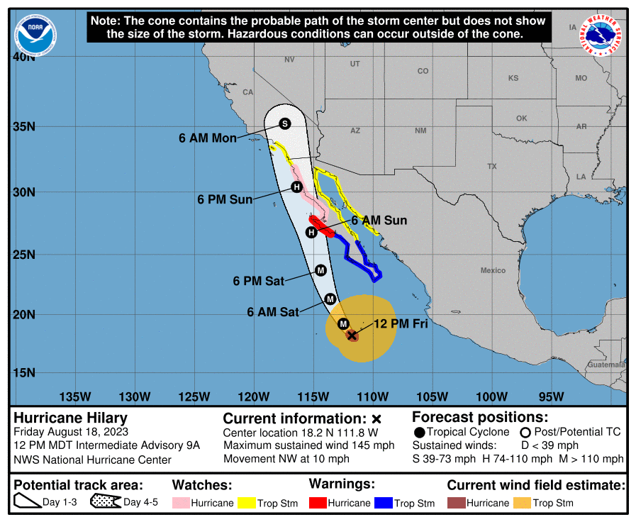
HURRICANE HILARY
Coastal Watches/Warnings and Forecast Cone for Storm Center
* If the storm is forecast to dissipate within 3 days, the “Full Forecast” and “3 day” graphic will be identical
Click Here for a 5-day Cone Printer Friendly Graphic
How to use the cone graphic (video):
About this product:
This graphic shows an approximate representation of coastal areas under a hurricane warning (red), hurricane watch (pink),
tropical storm warning (blue) and tropical storm watch (yellow). The orange circle indicates the current position of the
center of the tropical cyclone. The black line, when selected, and dots show the National Hurricane Center (NHC) forecast track of the center
at the times indicated. The dot indicating the forecast center location will be black if the cyclone is forecast to be
tropical and will be white with a black outline if the cyclone is forecast to be extratropical. If only an L is displayed,
then the system is forecast to be a remnant low. The letter inside the dot indicates the NHC’s forecast intensity for that time:
D: Tropical Depression – wind speed less than 39 MPH
S: Tropical Storm – wind speed between 39 MPH and 73 MPH
H: Hurricane – wind speed between 74 MPH and 110 MPH
M: Major Hurricane – wind speed greater than 110 MPH
NHC tropical cyclone forecast tracks can be in error. This forecast
uncertainty is conveyed by the track forecast “cone”, the solid white
and stippled white areas in the graphic. The solid white area depicts
the track forecast uncertainty for days 1-3 of the forecast, while the
stippled area depicts the uncertainty on days 4-5. Historical data
indicate that the entire 5-day path of the center of the tropical
cyclone will remain within the cone about 60-70% of the time. To
form the cone, a set of imaginary circles are placed along the
forecast track at the 12, 24, 36, 48, 72, 96, and 120 h positions,
where the size of each circle is set so that it encloses 67% of the
previous five years official forecast errors. The cone is then formed
by smoothly connecting the area swept out by the set of circles.
It is also important to realize that a tropical cyclone is not a point. Their
effects can span many hundreds of miles from the center. The area
experiencing hurricane force (one-minute average wind speeds of at least
74 mph) and tropical storm force (one-minute average wind speeds of
39-73 mph) winds can extend well beyond the white areas shown enclosing
the most likely track area of the center. The distribution of hurricane
and tropical storm force winds in this tropical cyclone can be seen in
the Wind History graphic linked above.
Considering the combined forecast uncertainties in track, intensity, and size, the
chances that any particular location will experience winds of 34 kt (tropical storm force),
50 kt, or 64 kt (hurricane force) from this tropical cyclone are presented in
tabular form for selected locations and forecast positions. This information is also presented in
graphical form for the 34 kt, 50 kt,
and 64 kt thresholds.
Note: A detailed definition of the NHC track forecast cone is also available.