Earthquake: 2024-09-02 04:13HKT M6.4 [6.83S, 155.49E] near Solomon Islands http://openstreetmap.org/?mlat=-6.83&mlon=155.49.
Source link
Strong Earthquake Report M6.1 [19.80S, 174.92W] near Tonga Islands (08:00 HKT 26/08/2024)
Earthquake: 2024-08-26 07:30HKT M6.1 [19.80S, 174.92W] near Tonga Islands http://openstreetmap.org/?mlat=-19.8&mlon=-174.92.
Source link
Advisory #003 Forecast Track [kmz] – Tropical Storm Hector (EP3/EP082024)
KMZ last updated Mon, 26 Aug 2024 08:37:48 GMT
Source link
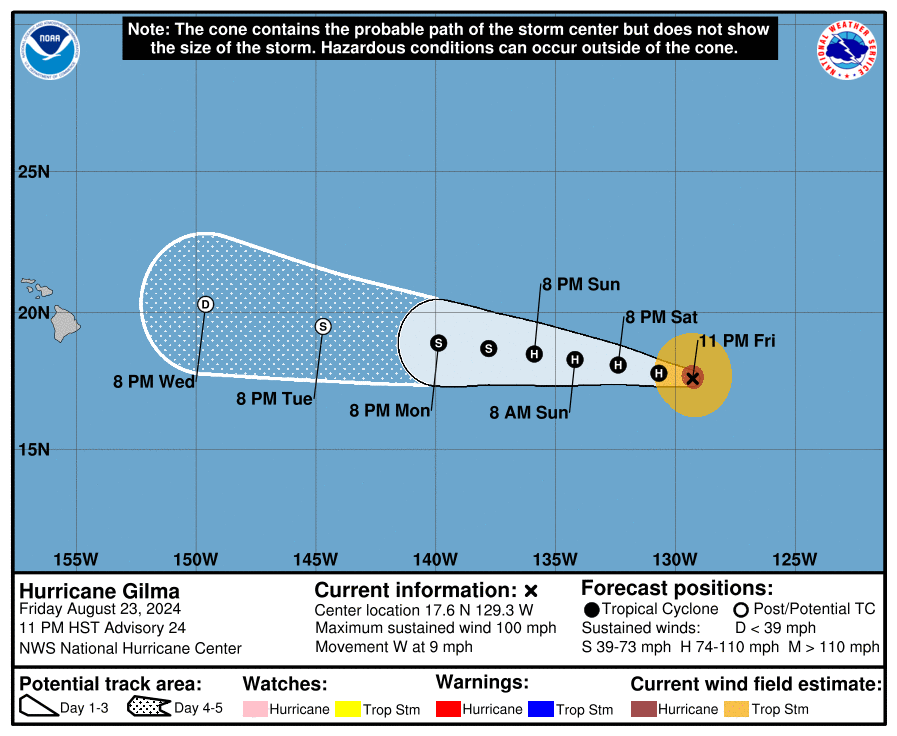
HURRICANE GILMA
HURRICANE GILMA
Coastal Watches/Warnings and Forecast Cone for Storm Center

* If the storm is forecast to dissipate within 3 days, the “Full Forecast” and “3 day” graphic will be identical
Click Here for a 5-day Cone Printer Friendly Graphic
How to use the cone graphic (video):

About this product:
This graphic shows an approximate representation of coastal areas under a hurricane warning (red), hurricane watch (pink),
tropical storm warning (blue) and tropical storm watch (yellow). The orange circle indicates the current position of the
center of the tropical cyclone. The black line, when selected, and dots show the National Hurricane Center (NHC) forecast track of the center
at the times indicated. The dot indicating the forecast center location will be black if the cyclone is forecast to be
tropical and will be white with a black outline if the cyclone is forecast to be extratropical. If only an L is displayed,
then the system is forecast to be a remnant low. The letter inside the dot indicates the NHC’s forecast intensity for that time:
D: Tropical Depression – wind speed less than 39 MPH
S: Tropical Storm – wind speed between 39 MPH and 73 MPH
H: Hurricane – wind speed between 74 MPH and 110 MPH
M: Major Hurricane – wind speed greater than 110 MPH
NHC tropical cyclone forecast tracks can be in error. This forecast
uncertainty is conveyed by the track forecast “cone”, the solid white
and stippled white areas in the graphic. The solid white area depicts
the track forecast uncertainty for days 1-3 of the forecast, while the
stippled area depicts the uncertainty on days 4-5. Historical data
indicate that the entire 5-day path of the center of the tropical
cyclone will remain within the cone about 60-70% of the time. To
form the cone, a set of imaginary circles are placed along the
forecast track at the 12, 24, 36, 48, 72, 96, and 120 h positions,
where the size of each circle is set so that it encloses 67% of the
previous five years official forecast errors. The cone is then formed
by smoothly connecting the area swept out by the set of circles.
It is also important to realize that a tropical cyclone is not a point. Their
effects can span many hundreds of miles from the center. The area
experiencing hurricane force (one-minute average wind speeds of at least
74 mph) and tropical storm force (one-minute average wind speeds of
39-73 mph) winds can extend well beyond the white areas shown enclosing
the most likely track area of the center. The distribution of hurricane
and tropical storm force winds in this tropical cyclone can be seen in
the Wind History graphic linked above.
Considering the combined forecast uncertainties in track, intensity, and size, the
chances that any particular location will experience winds of 34 kt (tropical storm force),
50 kt, or 64 kt (hurricane force) from this tropical cyclone are presented in
tabular form for selected locations and forecast positions. This information is also presented in
graphical form for the 34 kt, 50 kt,
and 64 kt thresholds.
Note: A detailed definition of the NHC track forecast cone is also available.
Advisory #008 Forecast Track [kmz] – Tropical Storm Gilma (EP2/EP072024)
KMZ last updated Tue, 20 Aug 2024 08:44:10 GMT
Source link
Strong Earthquake Report M6.9 [52.84N, 160.01E] off east coast of Kamchatka (03:22 HKT 18/08/2024)
Earthquake: 2024-08-18 03:10HKT M6.9 [52.84N, 160.01E] off east coast of Kamchatka http://openstreetmap.org/?mlat=52.84&mlon=160.01.
Source link
Advisory #027 Forecast Track [kmz] – Tropical Storm Ernesto (AT5/AL052024)
KMZ last updated Sun, 18 Aug 2024 09:11:56 GMT
Source link
Strong Earthquake Report M6.1 [23.84N, 121.73E] in Taiwan (07:48 HKT 16/08/2024)
Earthquake: 2024-08-16 07:35HKT M6.1 [23.84N, 121.73E] in Taiwan http://openstreetmap.org/?mlat=23.84&mlon=121.73.
Source link
Hurricane Ernesto Public Advisory
000
WTNT35 KNHC 161155
TCPAT5

BULLETIN
Hurricane Ernesto Intermediate Advisory Number 19A
NWS National Hurricane Center Miami FL       AL052024
800 AM AST Fri Aug 16 2024

...ERNESTO APPROACHING BERMUDA, WITH STRONG WINDS, DANGEROUS STORM
SURGE, AND LIFE-THREATENING FLOODING STARTING LATER TODAY...


SUMMARY OF 800 AM AST...1200 UTC...INFORMATION
----------------------------------------------
LOCATION...28.9N 66.5W
ABOUT 255 MI...415 KM SSW OF BERMUDA
MAXIMUM SUSTAINED WINDS...100 MPH...155 KM/H
PRESENT MOVEMENT...NNE OR 30 DEGREES AT 13 MPH...20 KM/H
MINIMUM CENTRAL PRESSURE...968 MB...28.59 INCHES


WATCHES AND WARNINGS
--------------------
CHANGES WITH THIS ADVISORY:

None.

SUMMARY OF WATCHES AND WARNINGS IN EFFECT:

A Hurricane Warning is in effect for...
* Bermuda

A Hurricane Warning means that hurricane conditions are expected
somewhere within the warning area.  Preparations to protect life
and property should be rushed to completion.

For storm information specific to your area, please monitor
products issued by your national meteorological service.


DISCUSSION AND OUTLOOK
----------------------
At 800 AM AST (1200 UTC), the center of Hurricane Ernesto was
located near latitude 28.9 North, longitude 66.5 West. Ernesto is
moving toward the north-northeast near 13 mph (20 km/h).  This
general motion is expected to continue today followed by a slower
north-northeastward motion on Saturday.  A faster northeastward
motion is expected late in the weekend.  On the forecast track, the
center of Ernesto is expected to pass near or over Bermuda on
Saturday.

Maximum sustained winds are near 100 mph (155 km/h) with higher
gusts.  Some strengthening is forecast during the next day or so,
and Ernesto is forecast to be a large hurricane near Bermuda on
Saturday and maintain hurricane strength through the weekend.

Ernesto is a large tropical cyclone. Hurricane-force winds extend
outward up to 70 miles (110 km) from the center and
tropical-storm-force winds extend outward up to 265 miles (425 km).

The estimated minimum central pressure is 968 mb (28.59 inches).


HAZARDS AFFECTING LAND
----------------------
Key messages for Ernesto can be found in the Tropical Cyclone
Discussion under AWIPS header MIATCDAT5 and WMO header WTNT45 KNHC
and on the web at hurricanes.gov/text/MIATCDAT5.shtml.

WIND: Hurricane conditions are expected on Bermuda Saturday, with
tropical storm conditions likely beginning later this afternoon.

STORM SURGE: A dangerous storm surge is expected to produce
significant coastal flooding on Bermuda in areas of onshore winds.
Near the coast, the surge will be accompanied by large and
destructive waves.

RAINFALL: Ernesto is expected to produce total rain accumulations of
6 to 12 inches in Bermuda with isolated maximum amounts up to 15
inches.  This rainfall will likely result in considerable
life-threatening flash flooding.

SURF: Swells generated by Ernesto are affecting portions of the
Turks and Caicos Islands, the Bahamas, and Bermuda.  Swells are
expected to spread up the east coast of the United States later
today and continue into the weekend, and could reach portions of
Atlantic Canada by late Saturday.  These swells are likely to cause
life-threatening surf and rip current conditions. Please consult
products from your local weather office, and stay out of the water
if advised by lifeguards.


NEXT ADVISORY
-------------
Next complete advisory at 1100 AM AST.

$$
Forecaster Papin
Advisory #003A Forecast Track [kmz] – Potential Tropical Cyclone Five (AT5/AL052024)
KMZ last updated Mon, 12 Aug 2024 11:55:37 GMT
Source link


