Earthquake: 2024-07-08 04:01HKT M6.0 [26.96N, 138.73E] near Ogasawara Islands, Japan Region http://openstreetmap.org/?mlat=26.96&mlon=138.73.
Source link
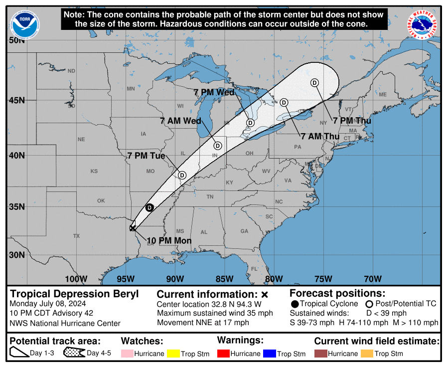
TROPICAL DEPRESSION BERYL
TROPICAL DEPRESSION BERYL
Coastal Watches/Warnings and Forecast Cone for Storm Center

* If the storm is forecast to dissipate within 3 days, the “Full Forecast” and “3 day” graphic will be identical
Click Here for a 5-day Cone Printer Friendly Graphic
How to use the cone graphic (video):

About this product:
This graphic shows an approximate representation of coastal areas under a hurricane warning (red), hurricane watch (pink),
tropical storm warning (blue) and tropical storm watch (yellow). The orange circle indicates the current position of the
center of the tropical cyclone. The black line, when selected, and dots show the National Hurricane Center (NHC) forecast track of the center
at the times indicated. The dot indicating the forecast center location will be black if the cyclone is forecast to be
tropical and will be white with a black outline if the cyclone is forecast to be extratropical. If only an L is displayed,
then the system is forecast to be a remnant low. The letter inside the dot indicates the NHC’s forecast intensity for that time:
D: Tropical Depression – wind speed less than 39 MPH
S: Tropical Storm – wind speed between 39 MPH and 73 MPH
H: Hurricane – wind speed between 74 MPH and 110 MPH
M: Major Hurricane – wind speed greater than 110 MPH
NHC tropical cyclone forecast tracks can be in error. This forecast
uncertainty is conveyed by the track forecast “cone”, the solid white
and stippled white areas in the graphic. The solid white area depicts
the track forecast uncertainty for days 1-3 of the forecast, while the
stippled area depicts the uncertainty on days 4-5. Historical data
indicate that the entire 5-day path of the center of the tropical
cyclone will remain within the cone about 60-70% of the time. To
form the cone, a set of imaginary circles are placed along the
forecast track at the 12, 24, 36, 48, 72, 96, and 120 h positions,
where the size of each circle is set so that it encloses 67% of the
previous five years official forecast errors. The cone is then formed
by smoothly connecting the area swept out by the set of circles.
It is also important to realize that a tropical cyclone is not a point. Their
effects can span many hundreds of miles from the center. The area
experiencing hurricane force (one-minute average wind speeds of at least
74 mph) and tropical storm force (one-minute average wind speeds of
39-73 mph) winds can extend well beyond the white areas shown enclosing
the most likely track area of the center. The distribution of hurricane
and tropical storm force winds in this tropical cyclone can be seen in
the Wind History graphic linked above.
Considering the combined forecast uncertainties in track, intensity, and size, the
chances that any particular location will experience winds of 34 kt (tropical storm force),
50 kt, or 64 kt (hurricane force) from this tropical cyclone are presented in
tabular form for selected locations and forecast positions. This information is also presented in
graphical form for the 34 kt, 50 kt,
and 64 kt thresholds.
Note: A detailed definition of the NHC track forecast cone is also available.
Advisory #003 Forecast Track [kmz] – Tropical Storm Aletta (EP1/EP012024)
KMZ last updated Fri, 05 Jul 2024 02:35:31 GMT
Source link
Advisory #018A Forecast Track [kmz] – Hurricane Beryl (AT2/AL022024)
KMZ last updated Wed, 03 Jul 2024 05:51:39 GMT
Source link
Tropical Storm Chris Public Advisory
000
WTNT33 KNHC 010257
TCPAT3

BULLETIN
Tropical Storm Chris Advisory Number   2
NWS National Hurricane Center Miami FL       AL032024
1000 PM CDT Sun Jun 30 2024

...DEPRESSION BECOMES TROPICAL STORM CHRIS...
...BRINGING HEAVY RAINFALL AND FLOODING OVER PORTIONS OF
EASTERN MEXICO...


SUMMARY OF 1000 PM CDT...0300 UTC...INFORMATION
-----------------------------------------------
LOCATION...20.0N 96.2W
ABOUT 105 MI...165 KM SE OF TUXPAN MEXICO
MAXIMUM SUSTAINED WINDS...40 MPH...65 KM/H
PRESENT MOVEMENT...W OR 280 DEGREES AT 13 MPH...20 KM/H
MINIMUM CENTRAL PRESSURE...1005 MB...29.68 INCHES


WATCHES AND WARNINGS
--------------------
CHANGES WITH THIS ADVISORY:

None.

SUMMARY OF WATCHES AND WARNINGS IN EFFECT:

A Tropical Storm Warning is in effect for...
* Cabo Rojo to Puerto Veracruz

A Tropical Storm Warning means that tropical storm conditions are
expected somewhere within the warning area, in this case within
the next 6 hours.

For storm information specific to your area, please monitor
products issued by your national meteorological service.


DISCUSSION AND OUTLOOK
----------------------
At 1000 PM CDT (0300 UTC), the center of Tropical Storm Chris was
located near latitude 20.0 North, longitude 96.2 West.  Chris is
moving toward the west near 13 mph (20 km/h), and this general
motion is expected during the next day or so.  On the forecast
track, the center will move inland early Monday.

Maximum sustained winds are near 40 mph (65 km/h) with higher gusts.
Chris will begin to weaken after landfall and will likely dissipate
later on Monday.

Tropical-storm-force winds extend outward up to 70 miles (110 km)
from the center.

The estimated minimum central pressure is 1005 mb (29.68 inches).


HAZARDS AFFECTING LAND
----------------------
Key messages for Chris can be found in the Tropical Cyclone
Discussion under AWIPS header MIATCDAT3 and WMO header WTNT43 KNHC.

RAINFALL: Chris is expected to produce rainfall totals of 4 to 8
inches across portions of eastern Mexico through Monday. Maximum
rainfall totals around 12 inches are possible across the higher
terrain of the Mexican states of Guanajuato, Queretaro, and San
Luis Potosi.  This rainfall will result in area of flooding, with
mudslides possible in areas of higher terrain.

For a complete depiction of forecast rainfall and flash flooding
associated with Tropical Storm Chris, please see the National
Weather Service Storm Total Rainfall Graphic, available at
hurricanes.gov/graphics_at3.shtml?rainqpf

WIND:  Tropical storm conditions are expected in the warning area
during the next few hours.


NEXT ADVISORY
-------------
Next intermediate advisory at 100 AM CDT.
Next complete advisory at 400 AM CDT.

$$
Forecaster Pasch
Strong Earthquake Report M6.9 [15.92S, 74.44W] near coast of Peru (13:46 HKT 28/06/2024)
Earthquake: 2024-06-28 13:36HKT M6.9 [15.92S, 74.44W] near coast of Peru http://openstreetmap.org/?mlat=-15.92&mlon=-74.44.
Source link
Strong Earthquake Report M6.4 [14.62S, 167.23E] near Vanuatu Islands (16:11 HKT 24/06/2024)
Earthquake: 2024-06-24 16:03HKT M6.4 [14.62S, 167.23E] near Vanuatu Islands http://openstreetmap.org/?mlat=-14.62&mlon=167.23.
Source link
Strong Earthquake Report M6.1 [10.54N, 62.50W] near coast of Venezuela (12:10 HKT 23/06/2024)
Earthquake: 2024-06-23 11:57HKT M6.1 [10.54N, 62.50W] near coast of Venezuela http://openstreetmap.org/?mlat=10.54&mlon=-62.5.
Source link
Local Statement for One (Houston / Galveston, TX)
832
WTUS84 KHGX 190322
HLSHGX
TXZ335>337-436-437-191130-

Potential Tropical Cyclone One Local Statement Advisory Number 6
National Weather Service Houston/Galveston TX  AL012024
1022 PM CDT Tue Jun 18 2024

This product covers Southeast Texas

**TROPICAL STORM WARNINGS CONTINUE ACROSS PORTIONS OF THE TEXAS COAST**

NEW INFORMATION
---------------

* CHANGES TO WATCHES AND WARNINGS:
    - None

* CURRENT WATCHES AND WARNINGS:
    - A Tropical Storm Warning is in effect for Brazoria Islands,
      Coastal Brazoria, Coastal Jackson, Coastal Matagorda, and
      Matagorda Islands

* STORM INFORMATION:
    - About 480 miles south-southeast of Galveston TX
    - 22.5N 93.0W
    - Storm Intensity 40 mph
    - Movement Northwest or 305 degrees at 7 mph

SITUATION OVERVIEW
------------------

Potential Tropical Cyclone One continues to move northwestward
through the southwest Gulf of Mexico. It may develop into a Tropical
Storm over the next 12 to 18 hours before making landfall in eastern
Mexico late Wednesday night or early Thursday morning. Despite it
making landfall in Mexico and regardless of development, it has a large
wind field that will bring hazardous marine and coastal conditions to
Southeast Texas. Starting at San Luis Pass, Tropical Storm Warnings are
in effect for the coast southwards. Occasional strong wind gusts will
be possible for the rest of the the southeast Texas coast, so a Wind
Advisory is also in effect from San Luis Pass to High Island. Strong
winds will also be felt over the coastal waters where wind gusts up to
50 knots will be possible causing seas to rise to near 18 feet.
Coastal Flood Warnings are in effect along the coast as well where up
to 2 to 4 feet of innundation is possible. Water may wash over low-
lying roadways with some beach access becoming impassable. Locally
heavy rainfall will be possible tonight through Wednesday afternoon
mainly for areas south of I-10. Minor urban and small stream flooding
is likely with a few instances of flash flooding possible. Winds will
slowly decrease through the day on Thursday, but elevated tides will
continue to be possible through Friday.

POTENTIAL IMPACTS
-----------------

* SURGE:
Protect against life-threatening surge having possible significant
impacts across the southeast Texas coast. Potential impacts in
this area include:
    - Areas of inundation with storm surge flooding accentuated by
      waves. Damage to several buildings, mainly near the coast.
    - Sections of near-shore escape routes and secondary roads become
      weakened or washed out, especially in usually vulnerable low
      spots.
    - Major beach erosion with heavy surf breaching dunes. Strong and
      numerous rip currents.
    - Moderate damage to marinas, docks, boardwalks, and piers.
      Several small craft broken away from moorings, especially in
      unprotected anchorages.

* FLOODING RAIN:
Protect against life-threatening rainfall flooding having possible
extensive impacts across areas south of the I-10 corridor. Potential
impacts include:
    - Major rainfall flooding may prompt many evacuations and rescues.
    - Rivers and tributaries may rapidly overflow their banks in
      multiple places. Small streams, creeks, canals, and ditches may
      become dangerous rivers. Flood control systems and barriers may
      become stressed.
    - Flood waters can enter many structures within multiple
      communities, some structures becoming uninhabitable or washed
      away. Many places where flood waters may cover escape routes.
      Streets and parking lots become rivers of moving water with
      underpasses submerged. Driving conditions become dangerous.
      Many road and bridge closures with some weakened or washed out.

Protect against dangerous rainfall flooding having possible limited
to significant impacts across the rest of southeast Texas.

* WIND:
Protect against hazardous wind having possible limited impacts across
the southeast Texas coast. Potential impacts in this area include:
    - Damage to porches, awnings, carports, sheds, and unanchored
      mobile homes. Unsecured lightweight objects blown about.
    - Many large tree limbs broken off. A few trees snapped or
      uprooted, but with greater numbers in places where trees are
      shallow rooted. Some fences and roadway signs blown over.
    - A few roads impassable from debris, particularly within urban
      or heavily wooded places. Hazardous driving conditions on
      bridges and other elevated roadways.
    - Scattered power and communications outages.

Elsewhere across Southeast Texas, little to no impact is anticipated.

* TORNADOES:
Protect against a tornado event having possible limited impacts
across Southeast Texas. Potential impacts include:
    - The occurrence of isolated tornadoes can hinder the execution
      of emergency plans during tropical events.
    - A few places may experience tornado damage, along with power
      and communications disruptions.
    - Locations could realize roofs peeled off buildings, chimneys
      toppled, mobile homes pushed off foundations or overturned,
      large tree tops and branches snapped off, shallow-rooted trees
      knocked over, moving vehicles blown off roads, and small boats
      pulled from moorings.

PRECAUTIONARY/PREPAREDNESS ACTIONS
----------------------------------

* EVACUATIONS:
 Follow the advice of local officials.

* OTHER PREPAREDNESS INFORMATION:
 Now is the time to complete all preparations to protect life and
property in accordance with your emergency plan. Ensure you are in a
safe location before the onset of strong winds or possible flooding.

Keep cell phones well charged. Cell phone chargers for automobiles
can be helpful, but be aware of your risk for deadly carbon monoxide
poisoning if your car is left idling in a garage or other poorly
ventilated area.

If you are a visitor, be sure to know the name of the city or town in
which you are staying and the name of the county or parish in which
it resides. Listen for these locations in local news updates. Pay
attention for instructions from local authorities.


Rapidly rising flood waters are deadly. If you are in a flood-prone
area, consider moving to higher ground. Never drive through a flooded
roadway. Remember, turn around don't drown!

Closely monitor weather.gov, NOAA Weather radio or local news outlets
for official storm information. Be ready to adapt to possible changes
to the forecast. Ensure you have multiple ways to receive weather
warnings.

* ADDITIONAL SOURCES OF INFORMATION:
- For information on appropriate preparations see ready.gov
- For information on creating an emergency plan see getagameplan.org
- For additional disaster preparedness information see redcross.org

NEXT UPDATE
-----------

The next local statement will be issued by the National Weather
Service in Houston/Galveston TX around 4 AM CDT, or sooner if
conditions warrant.

$$
Strong Earthquake Report M6.0 [15.76S, 74.41W] near coast of Peru (23:01 HKT 16/06/2024)
Earthquake: 2024-06-16 22:47HKT M6.0 [15.76S, 74.41W] near coast of Peru http://openstreetmap.org/?mlat=-15.76&mlon=-74.41.
Source link


