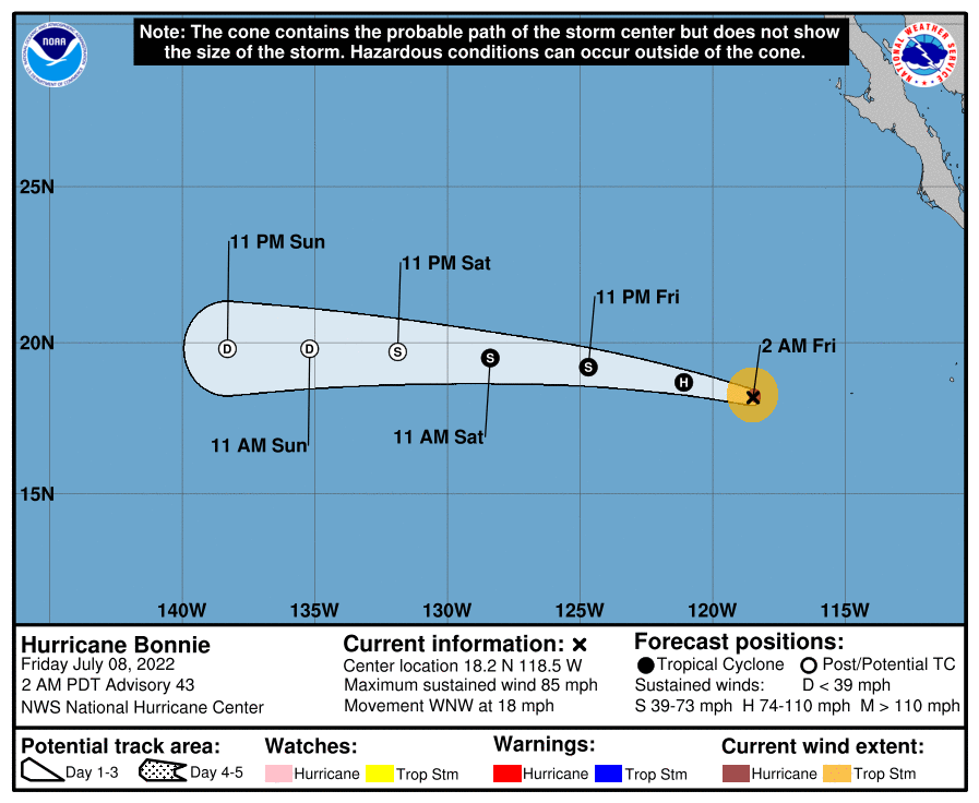
000
WTPZ45 KNHC 140901
TCDEP5

Hurricane Darby Discussion Number  20
NWS National Hurricane Center Miami FL       EP052022
Issued by NWS Central Pacific Hurricane Center Honolulu HI
1100 PM HST Wed Jul 13 2022

Darby's satellite presentation was still quite impressive near
analysis time this evening, with persistent cold cloud tops
surrounding a clear eye. However, some degradation in the cyclone's
appearance has been noted over the past couple of hours. The
eye has cooled and become a little elongated, and the cyclone
appears to be entraining environmental dry air, leading to
recently-observed breaks in the eye wall. The initial intensity is
estimated to be near 95 kt, representing a slight weakening from the
previous advisory, with Darby now below major hurricane strength.
This estimate is in line with a blend of the subjective Dvorak
intensity estimates from HFO/TAFB/SAB, the latest UW-CIMSS objective
Dvorak estimate of 95 kt, and a SATCON value of 97 kt.

Despite Darby holding its own over the past 24-36 hours,
significant weakening is anticipated over the next couple of days.
This is supported by all of the reliable guidance, with Darby
expected to dissipate by this weekend as it passes south of the
main Hawaiian Islands. The updated intensity forecast closely
follows the consensus IVCN, as well as the SHIPS guidance.

Darby lies on the southwestern periphery of a ridge aloft, in an
area characterized by light to moderate vertical wind shear. As
Darby is driven west-northwestward by a mid- and upper-level ridge
to the northeast in the short term, it will move closer to a
upper-level trough to it's northwest, into an environment
characterized by stronger vertical wind shear. This shear will
allow the cyclone to efficiently ingest the dry mid-level air that
prevails, while ths system moves over sub-26C SSTs. Darby is
expected to degrade to a shallow system over the next 48 hours, with
a persistent strong surface high north of Hawaii forcing Darby to
accelerate as it makes a turn toward the west. The updated track
forecast is close to the previous forecast, and lies very close to
the GFEX.

Darby is crossing into the central Pacific basin, and this will be
the final NHC advisory on this system. Future information on Darby
can be found in Forecast/Advisories issued by the Central Pacific
Hurricane Center beginning at 1500 UTC under AWIPS header HFOTCMCP1
and WMO header WTPA21 PHFO. For information specific to the
Hawaiian Islands, users should continue to consult products from
the National Weather Service Forecast Office in Honolulu, Hawaii,
at www.weather.gov/hfo.


FORECAST POSITIONS AND MAX WINDS

INIT  14/0900Z 16.2N 139.5W   95 KT 110 MPH
 12H  14/1800Z 16.6N 141.6W   85 KT 100 MPH
 24H  15/0600Z 17.0N 144.2W   70 KT  80 MPH
 36H  15/1800Z 17.1N 146.9W   55 KT  65 MPH
 48H  16/0600Z 17.0N 149.8W   40 KT  45 MPH...POST-TROPICAL
 60H  16/1800Z 16.9N 153.3W   30 KT  35 MPH...POST-TROP/REMNT LOW
 72H  17/0600Z...DISSIPATED

$$
Forecaster Birchard